
Low-flying Aircraft, High-stakes Geology: GNPC EXPLORCO Deepens Voltaian Basin Push
As a low-flying aircraft begins tracing tight gridlines over northern Ghana this month, the spectacle in the skies signals more than a technical survey. It marks the next decisive step in GNPC Explorco’s bid to de-risk the vast Voltaian Basin and reverse a troubling dip in national crude output—an assertive inland pivot at a moment when Ghana’s upstream future demands fresh geological conviction.
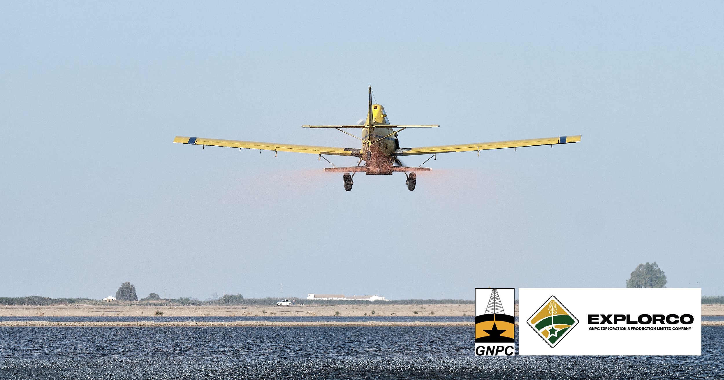
Voltaian Basin, Ghana | March 3, 2026 - Residents across swathes of northern and middle Ghana should expect an unfamiliar sight in the coming days: a low-flying aircraft tracing deliberate gridlines across the sky. The operation, led by GNPC Explorco, marks a fresh escalation in Ghana’s campaign to unlock new hydrocarbon frontiers at a time when crude output has softened, and upstream momentum is under pressure.
From March 1 to March 15, the specialised aircraft will conduct aerial geophysical surveys over Gushiegu, Mion, Nanumba North, Yendi, Buipe, Kwahu Afram Plains North and South, Sekyere Afram Plains and Agogo. Flights will run daily between 6:00 a.m. and 6:00 p.m., deliberately hugging lower altitudes than commercial aviation to optimise data acquisition.
The company is keen to pre-empt alarm. The low-altitude manoeuvres, it stresses, are controlled, professional and safe. Residents will see and hear the aircraft flying in systematic grid patterns, but the survey poses no threat to livestock, crops or property. Daily routines, the company insists, can continue uninterrupted.
A Technical Step in a Strategic Pivot
At first glance, the operation may seem procedural. In strategic terms, however, it is consequential.
Aerial geophysical surveys are foundational to basin screening. Using magnetics and, in some cases, radiometrics or gravity data, the aircraft captures variations in subsurface geological formations. These datasets help delineate sedimentary structures, fault lines and basin architecture—critical inputs for determining whether deeper seismic acquisition or exploratory drilling is justified.
In frontier basins, particularly onshore systems with limited legacy data, airborne surveys provide a relatively cost-efficient method of reducing geological uncertainty before committing to capital-intensive seismic campaigns. For Ghana, whose upstream narrative has long been dominated by offshore discoveries, the shift inland represents both a diversification strategy and a calculated risk.
The operation sits squarely within the broader Voltaian Basin programme—an ambitious attempt to convert a vast, underexplored sedimentary province into Ghana’s next petroleum chapter.
The Voltaian Equation
Covering roughly 103,600 square kilometres, the Voltaian Basin stretches across large parts of the country and has historically been regarded as geologically complex and commercially uncertain. Yet renewed geological interpretations and advances in exploration technology have revived its prospects.
GNPC Explorco has been central to this revival, positioning itself as the state’s vehicle for de-risking frontier acreage. In December, the company engaged stakeholders in Tamale, underscoring the technical, environmental and socio-economic dimensions of the upcoming campaign. Those engagements sought to manage expectations while reinforcing a message: exploration is a long game, but one with potentially transformative dividends.
The present aerial survey is a logical extension of that outreach—translating consultation into field activity.
Production Pressures and the Urgency Imperative
The timing is not incidental.
Ghana’s crude oil output declined by 25.9 per cent in the first half of 2025, according to the Public Interest and Accountability Committee (PIAC). Mature offshore fields have encountered natural decline curves, and incremental investments have not fully offset reservoir depletion. Against this backdrop, policy rhetoric has sharpened around the need to “increase production activities in the upstream.”
For Accra, the arithmetic is unforgiving. Hydrocarbon receipts remain material to fiscal stability, foreign exchange reserves and energy security planning. Without new discoveries or enhanced recovery, the production base risks gradual erosion.
The inland pivot—anchored by the Voltaian Basin—therefore represents more than a geological curiosity. It is a hedge against structural decline in the offshore portfolio.

Community Optics and Social Licence
Onshore exploration introduces a different political economy from offshore operations. Aircraft flying at low altitudes over farming communities is not a trivial matter. Perception management becomes as critical as technical execution.
By publicly detailing flight schedules, operational hours and safety assurances, GNPC Explorco is attempting to secure and maintain social licence. The explicit reassurance regarding livestock, crops and property reflects lessons drawn from other jurisdictions where insufficient communication has bred mistrust.
The company frames the exercise as a “national assignment”—a phrase that invokes collective ownership while subtly appealing for cooperation. It is a calibrated message: this is not speculative adventurism, but part of Ghana’s long-term development architecture.
From Data to Drill Bit: What Comes Next?
Aerial geophysics is a precursor, not a conclusion. Once processed and interpreted, the data will inform decisions on targeted seismic lines and, ultimately, exploratory drilling.
Drilling, expected in phases beginning in 2026 within selected Voltaian prospects, would constitute the true inflexion point. Positive results could reconfigure Ghana’s hydrocarbon geography, shifting part of the upstream value chain inland and catalysing infrastructure—roads, logistics hubs, potential processing facilities—in historically underdeveloped districts.
Failure, conversely, would underscore the high-risk nature of frontier basins and raise questions about capital allocation discipline.
Either outcome will be data-driven. For now, the aircraft’s disciplined gridlines across the northern sky symbolise a country methodically testing its geological thesis.
The Broader Strategic Frame
Globally, capital for upstream frontier exploration has tightened amid energy transition pressures and investor scrutiny over long-cycle fossil fuel projects. Ghana’s decision to intensify exploration—particularly onshore—signals confidence in its geological modelling and in the enduring role of hydrocarbons in its medium-term energy mix.
It also reflects a pragmatic assessment: energy transition pathways in emerging economies are unlikely to be linear. Domestic resource development remains a pillar of fiscal resilience and industrial policy.
In that context, the low-flying aircraft is more than a survey platform. It is a visible marker of Ghana’s determination to expand its upstream envelope, reduce geological blind spots and reposition the Voltaian Basin from speculative frontier to credible petroleum province.
For residents in Gushiegu, Yendi or the Afram Plains, the hum overhead may last only seconds. In Accra’s energy calculus, however, the implications extend well beyond mid-March.